Is it Hot or Just You?
Nation Enters First Heatwave Ahead of ‘Official’ Summer
For those who work outdoors, including roofers and other construction trades, a warming planet inspires a new index from the Centers for Disease Control

For the last several days, the National Oceanic and Atmospheric Administration’s National Weather Service has been sounding the alarm that a large swath of the continental United States will experience its first major heatwave of the season.
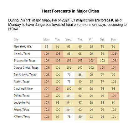
Beginning yesterday, rising temperatures will hit the South before stretching over the Midwest and spreading to the East Coast by midweek. From Texas to Maine, more than 22 million Americans will experience temperatures well into the 90s, with humidity pushing the heat index into triple digits, and all before Summer officially begins later this week.
The Weather Service said the severe heat rapidly developed ahead of a low-pressure system, spreading to the central Plains, Great Lakes region and Ohio Valley, and crawling northeast.
NOAA announced an excessive heat watch in effect from Monday to Friday for areas including Cleveland, Detroit, Pittsburgh, and Erie, Pa. Temperatures could surge well into the 90s during the day.
The heat wave was expected to push into the Northeast on Tuesday and continue through Saturday, the Weather Service said on social media on Sunday.
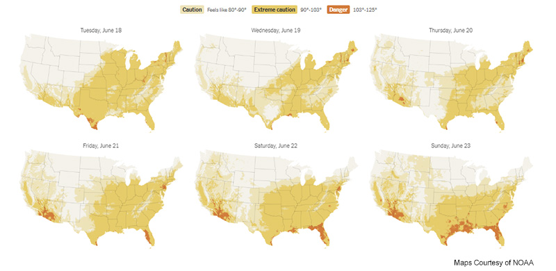
 “The combo of heat and humidity will produce heat index values 95 to around 105,” the office said, referring to how hot it feels outside.
Heat-related illnesses can range from minor to life-threatening. Mild heat illnesses can lead to heat rash, swelling in the hands and feet and muscle cramps, while heat exhaustion can cause headache, nausea, vomiting and dizziness.
Roofing contractors and laborers who work outdoors know the dangers of excessive heat. Every summer, warnings are consistently issued, reminding workers about the risks overheating has on their safety.
The number of consecutive months in which Earth's average global temperature has been the highest on record for that month has now reached 12; last month was the hottest May ever, and June could bring that number to 13, NOAA said.
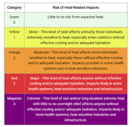 A New Scale
The National Weather Service and the Centers for Disease Control have created a new scale that gauges the health effects associated with extreme heat. The index, called “HeatRisk,” considers the duration of a heat wave and whether the temperature poses an elevated risk for an area based on C.D.C. data.
On a scale from No. 1-4, the new index gauges the health risks associated with extreme heat in a specific location on any given day. Because — as anyone who has spent summer days in Texas or Arizona could tell you — not all heat feels the same. Experts say even slightly lower temperatures and high humidity levels can be more dangerous.
The forecast for Monday indicates that parts of central Iowa, western Illinois, and Missouri (including Kansas City) have been rated as level 4, which is the most extreme level of risk. At this level, experts say the entire population is at risk, and a significant increase in emergency room visits is likely. As the heat wave expands, there will be high risks in cities such as Chicago, Cleveland, and Buffalo.

Is It Hot or Just Me? 5 Signs of Heat Stroke
The Mayo Clinic delineates five signs that you may be suffering from heat stroke, including:
- A body temperature of 104 degrees Fahrenheit or higher;
- An altered mental state or behavior such as confusion or agitation;
- Alteration in sweating with skin feeling hot and dry to the touch;
- Nausea, vomiting, and;
- A rapid heart rate.
Preventative measures include staying hydrated, wearing appropriate clothing, and avoiding excessive heat exposure. View more information on the HeatRisk scale here.
Looking for a reprint of this article?
From high-res PDFs to custom plaques, order your copy today!


